Geography of Ramnagar Nainital Uttarakhand
 |
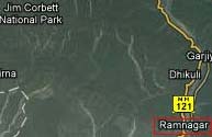
Ramnagar
Nainital Uttarakhand is located at 29.40°N 79.12°E.
Ramnagar Nainital Uttarakhand has an average elevation of 345 metres (1,132
feet). Ramnagar is located at the foothills of the Himalayas on the bank
of river Kosi. Kashipur located approximately 18 km away from this Ramnagar.
The Ramnagar town is well-known for being the gateway to Corbett National
Park and draws lot of tourist attention because of its geographical location.
Ramnagar proximity to Nainital 60 kms which is a famous hill station of
Northern India makes it even more popular. Ramnagar is the gateway to
western Kumaon and Garhwal. Ramnagar is also the commencement point of
Kumaon Hills with the nearby town of Haldwani.
Ramnagar is also famous for International "Litchi farming". There
is a Kosi Barrage in Ramnagar where lot of migratory birds arrives in
winter. Being a small town its culturally diverse, most of the people
in this town are either Kumaoni's or Garhwali's. The town has got several
public and private schools along with a collage for higher education offering
diverse, professional courses which makes the town complete from the education
point of view.
Primary source of income of Ramnagar town is tourism, government jobs,
individual shops and small-mid size businesses.
|
 Climate of Ramnagar - Weather of Ramnagar
|
The mean annual temperature in Ramnagar varies from 15°C to 35°C.
Total annual rainfall is nearly 205 cm.
|